Status: Members OnlyClosed for Lambingin March / April / May check other rules below and on Telegram |
|
|---|---|
| Site Latitude: N51.781327 | Height ASL Meters: 550m |
| Site Longitude: W003.139240 | Height ASL Feet: 1,800ft |
| Wind Direction: NNE – ENE | Height Top to Bottom Meters: 110m |
| Best Direction: NE | Height Top to Bottom Feet: 350ft |
| Minimum BHPA Rating Hang Gliding: BHPA CP rating | Members Status: Members Only |
| Minimum BHPA Rating Paragliding: BHPA CP rating | OS Grid Reference and Prefix: SO 215 096 |
Take-off
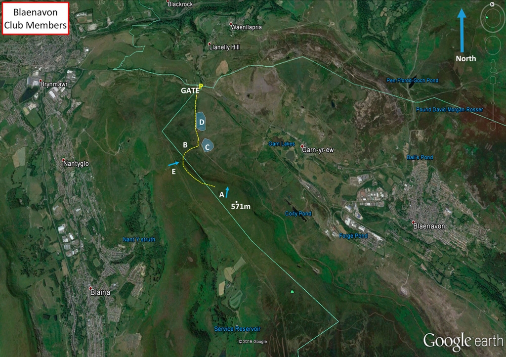
Access to take-off is by foot only (a hard carry up). Lots of space to rig on top of the hill, with an easy gentle rounded take-off. Take-off E for ENE to East, or take-off A when the wind has more North in it.
The take-off for Blaenavon is actually from the west side of the Coity Mountain. The hill is actually hollow as a labyrinth of coal mines lie below the hill!
Landing
Top landing area between (A) & (E) is vast, but the ground is rough and the front section slopes gently to the edge of the hill. Top landings should be carried out well away from pilots taking off. There is a fence that runs along the hill about 50mtrs behind take off. Slope landing by paragliders presents no real problems. The land between the hill and the road (B) is rough and broken and not recommended for hang glider bottom landing, however landings by paragliders are possible with care. Hang gliders should land on the other side of the road.
The obvious flat section of land (C) drops away sharply into a bog, on the side furthest away from the hill. Hang gliders need to make an accurate approach in order to avoid the likely consequences of an overshoot, bent metal. The bog already contains the remains of one aircraft, a Halifax Bomber (22nd May 1944). This area is easiest when the wind is off to the North. If in doubt land on the rough open common (D) to the North of the flat area, just before the embankment.
Top Landing General
South East Wales sites often have very large, undefined take off and top landing areas, which may change position according to conditions. To avoid the potential for collision, pilots making a top landing should keep well away from gliders taking off, who may in some cases have limited visibility.
Flying
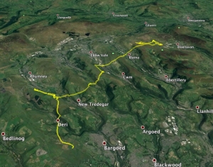
A fairly friendly site, particularly late in the day, though capacity is limited if the wind is off. A pleasant ridge run of around 5km (3 miles) to Varteg is possible in the right conditions.
Flying from the Coity Mountain can give you spectacular views. You’ll can see Big Pit, the Garn Lakes, the Blorenge, Clydach Gorge and across to the Black Mountains. If it’s not flyable then a guided trip down big pit is definitely worth it (it’s free) or a visit to the Garn Lakes (at the right time of year you might see a cuckoo).
Hazards
No real hazards. But the site is frequently used by schools and low airtime pilots, and can therefore become quite crowded.
Dogs are not permitted on the hillside. Please leave the gate as you find it. There will be a period of closure for between March and 15th May 2022 for Lambing; at the request of the Graziers during that period. If there are sheep with lambs settling on the mountain between these periods and the Closed for Flying sign is not on the gate, please advise the club and the closure period will commence. The club will notify members via our communication systems. If there are lambs on the hill then do not fly.
SEW Members Only Site. You must have in date membership subscription to SEWHGPGC. SEW helmet sticker to be stuck on your helmet at all times.
Walters Mining.
Some lovely and exciting XC flights can be achieved from Blaenavon. You’ll get to see some fantastic scenery over the valleys which were the industrial and coal minings centres of South Wales. Many of the industrial buildings remain.
The obvious route is in a north easterly wind to get enough height on the Blaenavon ridge from a thermal (often coming off the Big Pit mining museum area or Blaenavon town), before gliding back towards the Blaina ridge, then Ebbw Vale, Abertysswg ridge, Pontlottyn and so on. Becareful that you have enough height before going over the back of the ridges, especially when it’s windy as turbulence and rotor could be coming off the backs of all the ridges. Also beware of thermalling over and behind the wind turbines – expect there to be lots of turbulence behind them. Many of the turbines are inconveniently located right at that point thermals trigger off. Landing spots in the valley vary and it is often easier to land up on the tops of the ridges and walk down.
The valleys train lines run mostly north to south so are not that useful if you need to head east or west. It’s often easier to get a taxi than trying to hitch through the valley road system. or alternatively try to head north to the Heads of the Valleys road and hitch back east along this dual carriageway.
A memorable XC from Blaenavon by Alex Kennedy – stopping off at Pontlottyn to chat to other pilots before carrying on.
Site records –
PG – Alex Kennedy flew 11.6 km on his Nova Sector 06/06/2018 (www.paraglidingforum.com/leonardo/flight/1985585); Tony Aldous flew 16.2 km out and return (8.3 km open distance) on his Nova Factor 30/08/2010 (http://www.xcleague.com/xc/flights/20101927.html
A memorable XC flight by Alex Kennedy in 2018 – stopping off in Pontlottyn to chat to others before carrying on.
All rights belong to Google Inc. SEWHGPGC is a nonprofit making organisation.
If you require further advice about a particular SEWHGPGC site please contact a Club Coach. Please report all accidents to The Club Safety & Training Officer Steve Millson and the BHPA. Please visit the BHPA for the most current Incident Report Form.
This document is a guide only.
We advise that anyone Hang Gliding and Paragliding conduct a dynamic risk assessment prior to flying any site. This should be continuously re-assessed due to the changeable conditions of the outdoor environment.
All individuals are advised to take the following into account when making their dynamic risk assessment:
Paragliding and Hang Gliding are dangerous sports that can cause serious injury including bodily harm, paralysis and death. Flying SEW sites is undertaken with the full knowledge that Paragliding and Hang Gliding involves such risks. As the pilot you take exclusive responsibility for all risks associated with your part taking in the sport.
Any liability claims towards the club are excluded.
If you are not sure. DO NOT FLY.
In the Mountains/Rivers/Lakes
Dial 999/112 and ask for the Police and then Mountain Rescue. If you are away from the road side then dial 999/112 and ask for the Police and then Mountain Rescue explaining your circumstances. If you cannot make voice calls, you can now contact the 999 Emergency Services by SMS. NB you must register this prior to an emergency.
In an emergency 999 need to know:
Who is Calling?
Your name and mobile number.
What?
Briefly, what is the problem, including the state of the casualty. Ensure you use the buzzword Fall From Height
and Remote Location.
Where?
Coity Mountain 3.8km WNW of Blaenavon Village near Big Pit Museum just off the B4248. 3.2km SE of Brynmawr.
