Status: Open |
|
|---|---|
| Site Latitude: N51.804274 | Height ASL Meters: 520m |
| Site Longitude:W003.052774 | Height ASL Feet: 1,700ft |
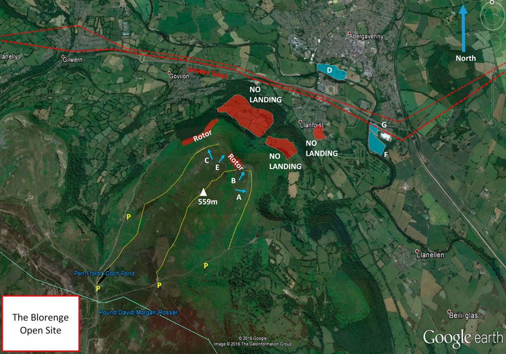
| Wind Direction: WNW - SE | Height Top to Bottom Meters: 480m |
| Best Direction: NNE | Height Top to Bottom Feet: 1,570ft |
| Minimum BHPA Rating Hang Gliding: BHPA CP rating | Member status: Open |
| Minimum BHPA Rating Paragliding: BHPA CP plus 15 hours; new pilots require site brief from CC/experienced pilot. | OS Grid Reference and Prefix: SO 274 123 |
Latitude: N51.790259
Longitude: W003.081824
Latitude: N51.790573
Longitude: W003.069620
Latitude: N51.792264
Longitude: W003.059462
From Abergavenny on the B4269 or from Llanfoist or Blaenavon on the B4246.
Park only in the car parks, do not park on the roads, verges or passing places. Parking on top of the mountain for key holders should be as far back from T/O as possible in lumpy ground behind hut.
Take-off
Vehicular access to take-off is restricted to approved permit holders only. Access for all other pilots is by foot only (a long carry up).
IMPORTANT: If taking off from the bowl, it is possible to feel the wind on your face, when in fact the prevailling wind is coming over the back and you will launch into rotor. Please use the weather station to ascertain the wind direction aligns with what you are taking off into.
The SE take-off is shallow. There is a risk of not clearing the ledge. The NE Bowl is a committed take-off, for paragliders there is a significant risk of not clearing the ledge below and so the flat take off area should be avoided. When windy it is often turbulent behind take off. Beware of being dragged into the Hut, or parked cars! Hang gliders should use a nose man whenever possible. Hang gliders should always take-off from the very edge of the bowl, even in nil wind. The Northwest take-off is quite friendly.
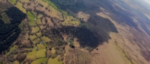
A view of the top of the Blorenge. The NE facing bowl is in the middle of the image, while the NW side of the Blorenge is on the right of the image. Photo courtesy of Harry Bloxham.
Landing
All top landings can be turbulent, land well back to avoid rotor. The SE top landing area (A) is difficult for hang gliders due to the angle of the slope. The NE top landing area (B) is rough ground, watch out for the craters towards the front. Paragliders slope landing in the NE Bowl should watch out for the trees. The NW top landing (C) is fairly smooth, but slopes gently towards take-off.
Paragliders slope landing below the NW face should watch out for rocks hidden in the bracken. Paragliders can sometimes find the bottom landing field at Castle Meadows (D) difficult to reach. Once over the power lines there is no turning back if met by heavy sink. Paragliders in any doubt about making it safely to Castle Meadows should make an early decision to slope land on the side of the Blorenge.
Landing fields F and G are only to be used in an emergency; for example when crossing the powerlines to Castle Meadows (D) is impossible due to an unfortunate encounter with sinking air. Access to these fields is via Faccenda, a Turkey processing plant accessible from the A465 westbound, approx 200m from the Hardwick Roundabout. There is plenty of parking available and drivers should explain to the security guards in the hut that they are accessing the property to recover paraglider pilots. Egress is onto the A4042 northbound which is shortly before the aforementioned roundabout.
Top Landing General
South East Wales sites often have very large, undefined take off and top landing areas, which may change position according to conditions. To avoid the potential for collision, pilots making a top landing should keep well away from gliders taking off, who may in some cases have limited visibility.
Flying
For live wind reports on the Blorenge click here.
A committing site which can accommodate 30 plus gliders when conditions are good, but less than 5 gliders if conditions deteriorate. The site to go to in light winds. It also has tremendous potential for triangle and out and return flights.
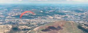
A view of the top of Blorenge, looking east – the Blorenge is just to the right of the red paraglider in the foreground. The Skirrid is visible to the east.
Hazards
Beware of high voltage power lines in the valley and rotor behind take-off.
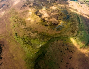
A view of the Punch Bowl on the East side of the Blorenge (photo taken from cloud base). Don’t try to land down here as there are no landing options.
All enclosed fields on the mountain are strictly out of bounds. This is a site of Special Scientific Interest – please treat it with respect it deserves. Dogs are not permitted on the hill.
Open site – This site may be flown by all suitably insured hang glider & paraglider pilots.
The Blorenge has been owned by the SE Wales Hang Gliding & Paragliding Club Ltd since 1998. It is designated an SSSI.
The Blorenge has some amazing XC potential for those light wind thermic days.
Site record
PG – Harry Bloxham, Luke Nichol, Mark Watts and Lawrie Noctor flew their Ozone Enzo 3s and Zeno 100.5 km (declared triangle earing 271.3 km in XCL points) on 07 July 2018.
http://www.xcleague.com/xc/flights/20182939.html
All rights belong to Google Inc. SEWHGPGC is a nonprofit making organisation.
If you require further advice about a particular SEWHGPGC site please contact a Club Coach. Please report all accidents to The Club Safety & Training Officer Steve Millson and the BHPA. Please visit the BHPA for the most current Incident Report Form.
This document is a guide only.
We advise that anyone Hang Gliding and Paragliding conduct a dynamic risk assessment prior to flying any site. This should be continuously re-assessed due to the changeable conditions of the outdoor environment.
All individuals are advised to take the following into account when making their dynamic risk assessment:
Paragliding and Hang Gliding are dangerous sports that can cause serious injury including bodily harm, paralysis and death. Flying SEW sites is undertaken with the full knowledge that Paragliding and Hang Gliding involves such risks. As the pilot you take exclusive responsibility for all risks associated with your part taking in the sport.
Any liability claims towards the club are excluded.
If you are not sure. DO NOT FLY.
In the Mountains/Rivers/Lakes
Dial 999/112 and ask for the Police and then Mountain Rescue. If you are away from the road side then dial 999/112 and ask for the Police and then Mountain Rescue explaining your circumstances. If you cannot make voice calls, you can now contact the 999 Emergency Services by SMS. NB you must register this prior to an emergency.
In an emergency 999 need to know:
Who is Calling?
Your name and mobile number.
What?
Briefly, what is the problem, including the state of the casualty. Ensure you use the buzzword Fall From Height
and Remote Location.
Where?
The Blorenge Mountain 3.4km SW of Abergavenny Town. Near A40/A465 interchange.
