Status: Members Only |
|
|---|---|
| Site Latitude:N51.858824 | Height ASL Meters:486 m |
| Site Longitude:W002.972886 | Height ASL Feet:1604ft |
| Wind Direction:ESE or NNE | Height Top to Bottom Meters:136 m |
| Best Direction: ESE | Height Top to Bottom Feet:449 ft |
| Minimum BHPA Rating Hang Gliding: BHPA CP rating (considered unsuitable due to the long walk up). | Member status:Members only site |
| Minimum BHPA Rating Paragliding:BHPA CP rating | OS Grid Reference and Prefix:SO 0330182 |
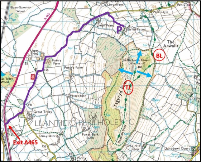
Choose to park at either Fairview (Skirrid farm) or the National Trust car park.
For Fairview: From Abergavenny, heading north on the A465, turn right towards “Pen y Parc”. The junction is approximately 200m after the Abergavenny/Mardy junction. Follow this minor road to the North, driving between the Poultry Farm and the Equestrian Centre. Three quarters of a mile after the Equestrian Centre, turn right up the farm track to Fairview. Park at point “P” in the flat portion of the field, just outside the entrance to the farm house in the field that slopes down towards the A465.
For the National Trust car park: From Abergavenny take the minor roads out to the east (B4233 or B4521). Pay at the car park.
National Trust car park
Latitude: N51.842077
Longitude: W002.976188
Fairview (Skirrid Farm):
Latitude: N051.864129
Longitude: W002.974811
There is a site fee of £5 per pilot, per day to be paid to Mrs Chandler on arrival at Fairview. Access is on foot through the farm gates and slightly uphill towards the SE. Keeping the dingle (wood) on your right-hand side, after 200m you will come to a gate. Go through or over this gate and continue SSE to intercept the junction of the edge of the farm fields and footpaths just to the NE of “BL” on the
map above. The landing field for the day can then be selected based on location of stock, wind direction and prior arrangement with Mrs Chandler at Fairview.
Access to take off is then via the footpath that ascends the ESE face, traversing to the SW up the gradual incline. The take off area is then to your north, along the spine.
Take-off
Take off areas are highlighted with blue arrows on the site map. They are near the trig point, and face NNE and ESE. There are other smaller and more technical take off areas further south along the ridge, but these are not suitable for training as they are too far from the landing area.
Most areas near the trig point are clear and unobstructed, although this is a popular picnic spot for hikers.
The take off to the WNW is committed as it steepens over the cliff, to the left of the photo the ground drops away before rising again sharply.
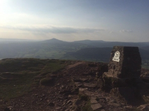 Looking west towards the Sugar Loaf Mountain from the Skirrid trig point. Photo courtesy of Alex Coltman.
Landing
The bottom landing area is marked “BL” in red on the site map. It is in the fields of Fairview Farm to the N and NE of the trig point, approximately a 450ft top to bottom flight. The actual field to be used should be discussed with Mrs Chandler before setting up for the day. Top landing is possible in light conditions on the spine back, or in stronger conditions about 500m south on a small plateau before the final ascent onto the main ridge. Top landing is difficult to teach at the site because the area is out of sight from the take off area and quite technical.
Top Landing General
South East Wales sites often have very large, undefined take off and top landing areas, which may change position according to conditions. To avoid the potential for collision, pilots making a top landing should keep well away from gliders taking off, who may in some cases have limited visibility.
Flying
The ridge is soarable in the right conditions. In thermic air you are advised not to try and soar close in to the terrain and it would be best to consider this an XC launch in strong thermic conditions.
Hazards
The site is a spine back ridge with all the associated hazards of such a site. The WNW face has a large scar and cliff at the north end. If soaring well below ridge height, severe turbulence should be expected from the raised ground in front of the cliff.
The WNW face is heavily wooded, and with the Equestrian Centre to the West, should only be soared in favourable conditions.
The ESE face has some bushes and small trees on the lower parts of the slope.
The site is a popular National Trust hiking route and large numbers of people can be expected to be on the hill, especially during holiday periods.
None.
Members only site – This site may be flown by suitably insured visiting hang glider & paraglider pilots.
This site is owned by the National Trust.
All rights belong to Google Inc. SEWHGPGC is a nonprofit making organisation.
If you require further advice about a particular SEWHGPGC site please contact a Club Coach. Please report all accidents to The Club Safety & Training Officer Steve Millson and the BHPA. Please visit the BHPA for the most current Incident Report Form.
This document is a guide only.
We advise that anyone Hang Gliding and Paragliding conduct a dynamic risk assessment prior to flying any site. This should be continuously re-assessed due to the changeable conditions of the outdoor environment.
All individuals are advised to take the following into account when making their dynamic risk assessment:
Paragliding and Hang Gliding are dangerous sports that can cause serious injury including bodily harm, paralysis and death. Flying SEW sites is undertaken with the full knowledge that Paragliding and Hang Gliding involves such risks. As the pilot you take exclusive responsibility for all risks associated with your part taking in the sport.
Any liability claims towards the club are excluded.
If you are not sure. DO NOT FLY.
In the Mountains/Rivers/Lakes
Dial 999/112 and ask for the Police and then Mountain Rescue. If you are away from the road side then dial 999/112 and ask for the Police and then Mountain Rescue explaining your circumstances. If you cannot make voice calls, you can now contact the 999 Emergency Services by SMS. NB you must register this prior to an emergency.
In an emergency 999 need to know:
Who is Calling?
Your name and mobile number.
What?
Briefly, what is the problem, including the state of the casualty. Ensure you use the buzzword Fall From Height
and Remote Location.
Where?
Due to the size of this site and the potential dangers of operating in a mountainous environment with the inherent changeable conditions associated with such environments. Individuals are advised to be competent at calling in the emergency services and giving co-ordinates themselves.
The nearest hospital for the Skirrid is Neville Hall Hospital, Abergavenny.
