Status: Open |
|
|---|---|
| Site Latitude:N51.723490 | Height ASL Meters:481m |
| Site Longitude:W003.303700 | Height ASL Feet:1578ft |
| Wind Direction:All | Height Top to Bottom Meters:Various |
| Best Direction: SW & NNE | Height Top to Bottom Feet:Various |
| Minimum BHPA Rating Hang Gliding: BHPA CP rating | Member status:Members Only |
| Minimum BHPA Rating Paragliding:BHPA CP rating | OS Grid Reference and Prefix:SO 100 035 |
Latitude: N51.719456
Longitude: W003.296998
Latitude: N51.718887
Longitude: W003.306134
From Fochriw flying site continue with the site on your right until you reach a junction. Turn right and immediately right onto A4255 towards Bedlinog, follow past the cemetery until you reach a right turn. Car park on your right.
Please park in the car park, lat/long above.
Take-off
The best directions for this hill are WSW-SW and NNE-NE.
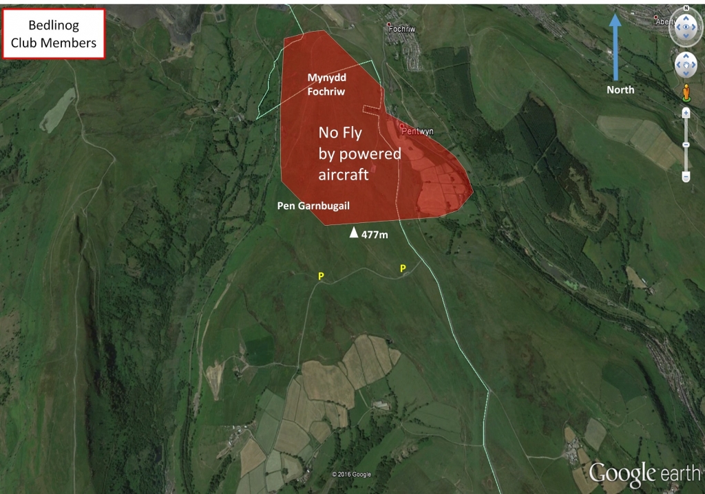
No taking off at the trig point for powered aircraft.
Landing
Land anywhere, however not in the valley between Bedlinog and Merthyr to the west.
Top Landing General
South East Wales sites often have very large, undefined take off and top landing areas, which may change position according to conditions. To avoid the potential for collision, pilots making a top landing should keep well away from gliders taking off, who may in some cases have limited visibility.
Flying
This is not the best of flying sites, but is good for ground handling as the area is wide open with gentle slopes all round. The SW and NE slopes are steeper but do not have a great height difference. The hill can be used as a top up for XC from Merthyr direction.
Hazards
The area is open grazing land, covered in grass with few exposed rocks and gullies. There is a real problem with fly tipping and hypodermic needles have been found in the area of the car park. Livestock graze the land and wild horses roam freely. The NE slope does have issues with the local grazier from the farm to the NE, however he does not have any legal ownership of the land.
A recognised Paramotor Take-off and Landing area (see paramotoring noted below).
Paramotor:
This is commonly used take-off for paramotoring. Great trips include: to the Brecon Beacons, along the mountain railway, to Pontsticill reservoir to the north or a visit to the Pit Pony (great to see from the sky) to the south.
Park in the car park and take off on the flat area just in front (it slopes slightly downhill to the south). Do not drive onto the grass.
Take off is possible in most directions, but if it is a northerly (the take-off is slightly up hill) or easterly (take-off limited by boggy overgrown ground), you are much better off moving to Gelligaer Common. If it has been raining Gelligaer common may be a better bet too. It is common to find sheep and horses on the top. They tend to move away once the motor starts up, but be careful. If it’s your first time here, you should familiarise yourself with where any rocks are. Expect many passersby to get out and video you on their phone – if you would prefer to avoid this then go to Gelligaer Common where you can be more out of sight.
Paramotoring rules:
Do not overfly the farm to the east of Bedlinog. Do not use the trig point as a launch point.
Do not fly low over urban areas.
Open site – This site may be flown by suitably insured visiting hang glider & paraglider pilots.
TBC
Not known if any XC flights have left from here but can be used as a top up if at height.
All rights belong to Google Inc. SEWHGPGC is a nonprofit making organisation.
If you require further advice about a particular SEWHGPGC site please contact a Club Coach. Please report all accidents to The Club Safety & Training Officer Steve Millson and the BHPA. Please visit the BHPA for the most current Incident Report Form.
This document is a guide only.
We advise that anyone Hang Gliding and Paragliding conduct a dynamic risk assessment prior to flying any site. This should be continuously re-assessed due to the changeable conditions of the outdoor environment.
All individuals are advised to take the following into account when making their dynamic risk assessment:
Paragliding and Hang Gliding are dangerous sports that can cause serious injury including bodily harm, paralysis and death. Flying SEW sites is undertaken with the full knowledge that Paragliding and Hang Gliding involves such risks. As the pilot you take exclusive responsibility for all risks associated with your part taking in the sport.
Any liability claims towards the club are excluded.
If you are not sure. DO NOT FLY.
In the Mountains/Rivers/Lakes
Dial 999/112 and ask for the Police and then Mountain Rescue. If you are away from the road side then dial 999/112 and ask for the Police and then Mountain Rescue explaining your circumstances. If you cannot make voice calls, you can now contact the 999 Emergency Services by SMS. NB you must register this prior to an emergency.
In an emergency 999 need to know:
Who is Calling?
Your name and mobile number.
What?
Briefly, what is the problem, including the state of the casualty. Ensure you use the buzzword Fall From Height
and Remote Location.
Where?
Bedlinog Common, 2.2km NNW of Bedlinog village.
