Nant-y-moel

Status: Members Only
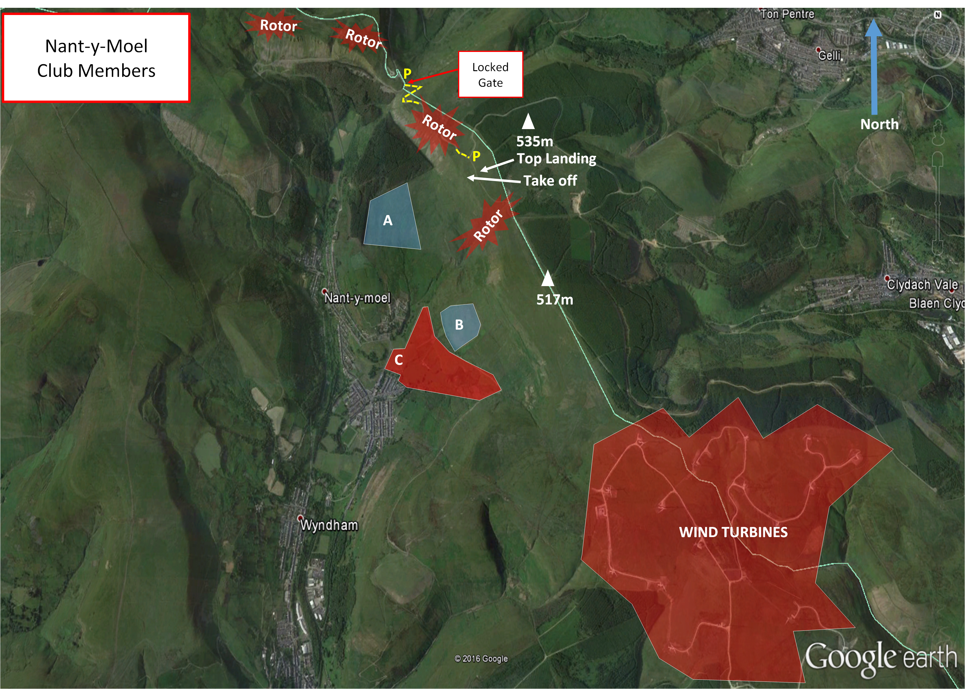
Site Latitude:N51.633150 Height ASL Meters:490m
Site Longitude:W003.525706 Height ASL Feet:1600ft
Wind Direction:SSW-WSW Height Top to Bottom Meters:335
Best Direction: SW Height Top to Bottom Feet:1100
Minimum BHPA Rating Hang Gliding: BHPA Pilot rating Member status:Members Only
Minimum BHPA Rating Paragliding:BHPA Club Pilot rating OS Grid Reference and Prefix:SS 944 938

Latitude: N51.639263
Longitude: W003.534609

Latitude: N51.633084
Longitude: W003.525731

Keep the gate locked at all times!
Do not leave the gate open or unattended ever.
access / replacing the lock or keys takes up time and puts pressure on our access agreements.
From M4 J36 at Bridgend or from the Rhondda on A4061. Alternatively from Maesteg and Port Talbot on A4017. Vehicular access to take is via rough track by kind permission of the landowners. A locked gate is fitted across the track entrance and only key-holders should leave cars parked on top of the hill adjacent the take-off area. Non key-holders can drive to the top if the gate is found open, but only to drop off equipment and you should not leave your cars parked on the top as once the gate is locked as you will be trapped inside the gate (please note there is currently no local contact available to unlock the gate under such circumstances, you have been warned)
Keep the gate locked at all times! Do not leave the gate open or unattended ever. Regaining access / replacing the lock or keys takes up time and puts pressure on our access agreements.
Non-key holders should park in the public lay-bys near to the road entrance to the track.
Do not park on top unless you have a gate key, you will almost certainly get locked in and there is no contact to unlock the gate and let you out.

Take-off

Vehicular access to take-off is restricted to key holders (keys can be obtained from the club with a refundable deposit, see
webcollect for details).
Keep the gate locked at all times! Do not leave the gate open or unattended ever. Regaining access / replacing the lock or keys takes up time and puts pressure on our access agreements.
Access for all other pilots is by foot only (around a 20 minute carry up), although drop-off of equipment is
allowed if the gate is open and there are pilots with keys on the hill (please note it is your own responsibility to ensure that you do not become trapped inside the gate).
The main take-off is shallow and relatively easy for the proficient pilot. Beware of rotor behind the cliffs to the north of the take-off, above the trees, and the gully immediately to the south of take-off. This is a thermic site, which is subject to sea breeze, and it can be turbulent at times.

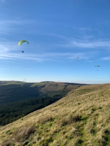
Looking along the Nant-y-moel take-off to the west. Photo courtesy of Marcus Woodbridge.

Landing

The best top landing is behind take off (beyond the track) but it and indeed the take-off area can be turbulent in all wind directions. The scree slope to the north of take-off above the trees should be avoided (note it is not suitable for any form of slope landing)
Slope landings in front of take-off are allowed, but watch out for the odd rock and hole in the long grass!
Pilots can land on the rough ground in front of take-off just beyond the stone wall (A) which is bounded on two sides by
trees and the other two sides by a wire fence, but note it is rough and a deceivingly long and hard carry out. An alternative is the rough ground to the east of the track (B) which offers an easier walk out along the zig-zag track.
Do not land in the fenced fields adjacent to the track (C) as they often have stock or horses in them and do not land in the main sports fields in the village

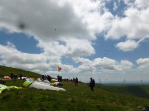
A busy take-off on Mynydd William Meyrick (Nant-y-Moel) at the British Club Challenge. Photo courtesy of Alan Hole.

Top Landing General

South East Wales sites often have very large, undefined take off and top landing areas, which may change position according to conditions. To avoid the potential for collision, pilots making a top landing should keep well away from gliders taking off, who may in some cases have limited visibility.

Flying

A relatively friendly site in the midst of the Spectacular Rhondda. The site has, however, its own microclimate and can
become turbulent as the winds start to become southerly or westerly or if sea breeze starts to reach the site, which can be
as early as midday in good XC conditions. Once the sea breeze has become established conditions generally stabilise, but
there is generally little if any XC potential thereafter. There is often a restitution towards the end of a good summer day,
which provides relaxed chilled out flying.
The site has great XC potential but beware of the deep steep sided valleys behind the hill and onwards toward Merthyr
Common, which suffer from both sea-breeze and valley-wind effects than can easily catch even the experienced pilot out. It
is recommended to stay safe and land on top if you do leave the hill and go XC

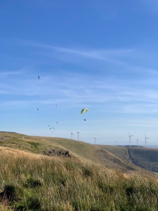
Looking east towards the wind farms at Nant-y-moel. Photo courtesy of Marcus Woodbridge.

Hazards

Rotor behind take-off and above the gully to the south of take-off, especially when there is a strong westerly or southerly
wind.
Modellers use the site regularly (sometimes for large world ranked competitions). The recognised protocol is to stay well
clear of them and not fly through the area they are using, if in doubt go and have a friendly chat with them before flying,
they are generally a friendly bunch and take safety (both ours and theirs) seriously.
Keep the gate locked at all times!
Do not leave the gate open or unattended ever.
Regaining access / replacing the lock or keys takes up time and puts pressure on our access agreements.
All enclosed fields on the mountain are strictly out of bounds.
Dogs must be kept on a lead to prevent issues with live-stock.
SEW Members Only Site.
You must have in date membership subscription to SEWHGPGC.
SEW helmet sticker to be stuck on your helmet at all times.
Nant-y-moel amazing XC potential in light SW’ly winds and thermic days. Flights to Brecon, Abergavenny and beyond are relatively common. Flights generally head along the heads of the valleys but beware of the steep sided valleys on-route especially those in the section between Nant-y-moel and Merthyr Common, they suffer either valley wind or sea-breeze affects and sometimes a mixture of both that can catch out even the most experienced XC pilot.
Site record
PG – Richard Chambers flew on his 134.3 km on his Advance Sigma 8 on 17 May 2014.
http://www.xcleague.com/xc/flights/20141164.html

All rights belong to Google Inc. SEWHGPGC is a nonprofit making organisation.

If you require further advice about a particular SEWHGPGC site please contact a Club Coach. Please report all accidents to The Club Safety & Training Officer Steve Millson and the BHPA. Please visit the BHPA for the most current Incident Report Form.

This document is a guide only.

We advise that anyone Hang Gliding and Paragliding conduct a dynamic risk assessment prior to flying any site. This should be continuously re-assessed due to the changeable conditions of the outdoor environment.

All individuals are advised to take the following into account when making their dynamic risk assessment:

Paragliding and Hang Gliding are dangerous sports that can cause serious injury including bodily harm, paralysis and death. Flying SEW sites is undertaken with the full knowledge that Paragliding and Hang Gliding involves such risks. As the pilot you take exclusive responsibility for all risks associated with your part taking in the sport.

Any liability claims towards the club are excluded.


If you are not sure. DO NOT FLY.

In the Mountains/Rivers/Lakes

Dial 999/112 and ask for the Police and then Mountain Rescue. If you are away from the road side then dial 999/112 and ask for the Police and then Mountain Rescue explaining your circumstances. If you cannot make voice calls, you can now contact the 999 Emergency Services by SMS. NB you must register this prior to an emergency.

In an emergency 999 need to know:

Who is Calling?

Your name and mobile number.

What?

Briefly, what is the problem, including the state of the casualty. Ensure you use the buzzword Fall From Height

and Remote Location.

Where?

Nant-y-Moel Mountain 1.42km NE of Nant-y-moel village. Best access will be on the Mountain road near the A4107 &
A4061 interchange