Status: Open |
|
|---|---|
| Site Latitude: N 51.733383 | Height ASL Meters: 480 m |
| Site Longitude: W 003.190582 | Height ASL Feet: 1800 ft |
| Wind Direction: ENE – ESE | Height Top to Bottom Meters: 220m |
| Best Direction: ENE | Height Top to Bottom Feet: 721ft |
| Minimum BHPA Rating Hang Gliding: BHPA Pilot rating | Member status: Open Site |
| Minimum BHPA Rating Paragliding: BHPA Pilot rating | OS Grid Reference and Prefix: SO 170 060 |
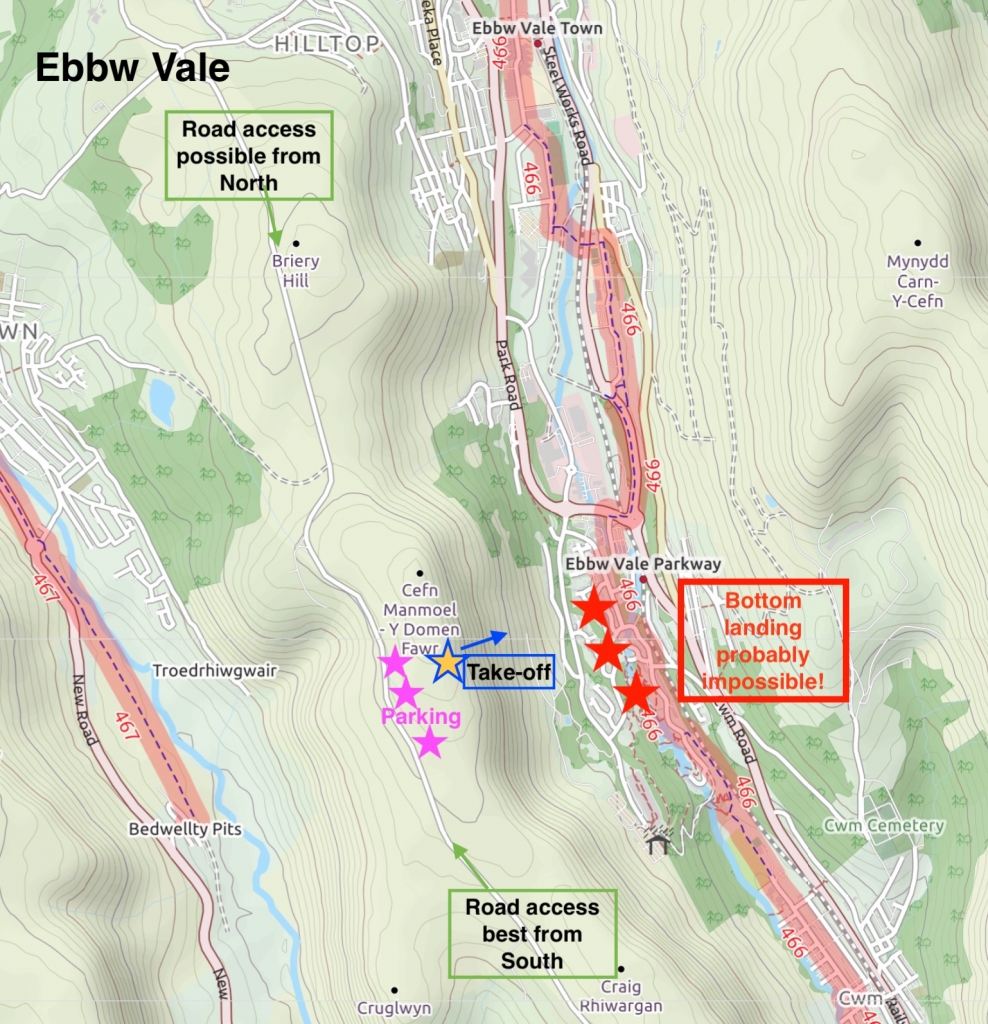
The site can easily be accessed from either the South (preferrable) or North onto Man Moel Common via the Manmoel Road. If coming from the North it is probably better to approach from the steep road which comes up from Cwm (see description below). Take-off is actually on the hill Cefn Manmoel.
Via Cwm – From the A465 “Heads of the Valleys” road take the A4046 to Ebbw Vale. Continue south on the A4046 driving just past the village of Cwm on your right hand side. At the next round about take the 3rd exit and enter the south side of Cwm. Then take the first turning on the left up a steep hill, this is marked with a sign post showing cycle route 466. Follow the hill to the top and take a right turn onto Manmoel road at the T-junction. Continue on Manmoel road towards the hill. Eventually you will pass over a cattle grid, drive for another 100-200 m.
Parking is along the side of the road. Do not drive onto the common.
Take-off
Access to take off is by foot by walking from the road onto Manmoel Common. The take-off is actually on the hill 0f Cefn Manmoel which forms part of the common. The take-off area is large and flat with a nice rounded front to the hill.
Take care not to stumble in the subsidence cracks near take off as these can be obscured by ground cover. There are also several ridges running parallel across the side of the hill that should be observed.
Landing
The top landing area is large, flat and free from any real obstructions although beware of the two water connection pipes that stick up in the air about 1 metre. There is also a large flat shoulder to the north of take-off. This can be turbulent if the wind is off to the south.
There is no suitable bottom landing field. Paraglider pilots can slope land on the front of the hill but should be aware of the rough nature of the ground.
Top Landing General
South East Wales sites often have very large, undefined take off and top landing areas, which may change position according to conditions. To avoid the potential for collision, pilots making a top landing should keep well away from gliders taking off, who may in some cases have limited visibility.
Flying
A nice site to fly which is under-used really considering the good road access and top landing area. Wave is not uncommon and good height gains are possible even in winter.
Can be a good alternative to Pandy.
Hazards
Watch out for subsidence cracks near take off and ridges running parallel across the sides of the hill. Water pipes sticking up about 1 metre on the top of the hill.
Beware of the wind turbines on the back of the hill, especially if going XC – there will be significant turbulence down wind of them.
Site records
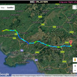
PG – Nick Roberts flew 82.8 km on his Advance Sigma 9 on 02 May 2017.
Maps courtesy of OpenStreetMap Contributors.
If you require further advice about a particular SEWHGPGC site please contact a Club Coach. Please report all accidents to The Club Safety & Training Officer Steve Millson and the BHPA. Please visit the BHPA for the most current Incident Report Form.
This document is a guide only.
We advise that anyone Hang Gliding and Paragliding conduct a dynamic risk assessment prior to flying any site. This should be continuously re-assessed due to the changeable conditions of the outdoor environment.
All individuals are advised to take the following into account when making their dynamic risk assessment:
Paragliding and Hang Gliding are dangerous sports that can cause serious injury including bodily harm, paralysis and death. Flying SEW sites is undertaken with the full knowledge that Paragliding and Hang Gliding involves such risks. As the pilot you take exclusive responsibility for all risks associated with your part taking in the sport.
Any liability claims towards the club are excluded.
If you are not sure. DO NOT FLY.
In the Mountains/Rivers/Lakes
Dial 999/112 and ask for the Police and then Mountain Rescue. If you are away from the road side then dial 999/112 and ask for the Police and then Mountain Rescue explaining your circumstances. If you cannot make voice calls, you can now contact the 999 Emergency Services by SMS. NB you must register this prior to an emergency.
In an emergency 999 need to know:
Who is Calling?
Your name and mobile number.
What?
Briefly, what is the problem, including the state of the casualty. Ensure you use the buzzword Fall From Height
and Remote Location.
Where?
OS Grid Ref: SO 170 060
2km north of Manmoel on single track road
