The following routes are great starting points for anyone interested in a bit of hike and fly in our local hills. Use these routes to practice all the aspects listed in the concept section. Plot the routes in advance, compare the weather to the forecast and actual from the Blorenge wind station, perfect your management of equipment and learn your vital statistics regarding speed/time. If the forecast doesn’t favour any of these routes, look for your own.
SEWHGPGC is blessed with two fantastic club sites that are perfect for hike and fly, and cover every wind direction. If the forecast wind is light, one of these two hills is always flyable and offers a 500m hike to take-off.
Use these two hills to practise using the equipment, learn the apps and learn about yourself. Two hiking routes are shown below, practice using your mapping app to plot your own route.
This is a simple route to fly in the right conditions but in marginal conditions is a huge amount of fun to complete as a hike and fly. The terrain is beautiful and relatively forgiving for slope landing and walking. Thermals are not required (although they do make it easier) so this can be attempted any time of the year. You might consider teaming up with some others and leaving cars at either end, attempting it as an out and return or even as a Vol Biv.
Hay Bluff – Crickhowell 20km
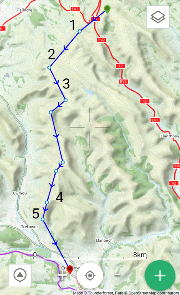
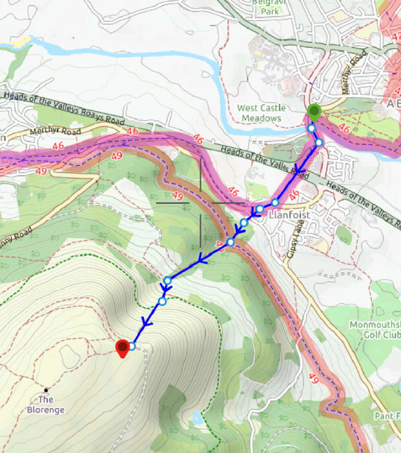
The walk from Hay Bluff car park to take-off isn’t long and puts you at the start of a superb hike and fly route to Crickhowell which will be different every time you attempt it. Once airborne, you face an immediate crux: crossing to Twmpa (Lord Hereford’s Knob) [Point 1]. In thermic conditions this isn’t too difficult but on a ridge running kind of day the push forward might be hard. You can experiment with the crossing (advise not being too close to the hill in a more westerly wind as you approach Twmpa) but ultimately, if you find yourself too low to soar back up a slope landing and short hike gets you back on the ridge. Alternatively, don’t launch from Hay Bluff and instead walk from Gospel Pass and launch somewhere near Twmpa.
From Twmpa you will have a stunning flight along the cliffs towards The Dragon’s Back, normally in the company of crows, kites and buzzards. As you approach Y Das, slow down and start to look for some height. It’s tempting to push on to Y Das and on a thermic day it can work well but, when ridge soaring, it’s a bit of a sink hole. If you look at the topography and think about how the air will flow around it, you might see why. A better place to pause is above the cliffs of Pen Rhos Dirion [Point 2].
Your next move is quite a tricky jump back towards Waun Fach over a couple of bowls and ridges so this should not be attempted low. If you are low, top land and walk to the rise of Pen y Manllwyn [Point 3] or further towards Waun Fach to launch again.
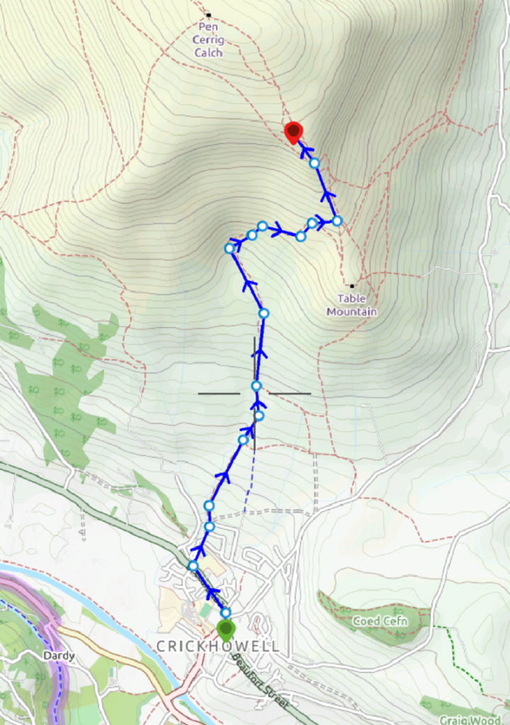
If the wind is too westerly to fly this first section, it’s a beautiful and easy 9km walk along the top of the ridge to Pen y Manllwyn [Point 3] where you will likely be able to get airborne and find an easy ride to Crickhowell.
The westerly ridge of the Black Mountains consists of several large bowls and features that you will move through so a good knowledge of their orientation will help you determine which are the most soarable faces. This ridge isn’t a clear run to Crickhowell when the winds are light. There are a couple of sections that are very shallow with plateaus and small ridges that can be confusing when trying to decide where to fly. Aiming higher if you can seems to work. Don’t fall fowl of soaring too low thinking the next ridge will keep you up – in light winds there is generally no wind lower down. The best thing to do in light conditions is land and walk to the top of the ridge to re-launch. Kiting along the top of the ridge is also a very useful method of covering this section.
(https://youtu.be/2aAgNmMU9wA)
The final feature along the ridge is Pen Allt-mawr [Point 4]. A magnificent steep face which will give you the height you need for the final 5km glide to Crickhowell. If you are low when you reach it, be careful. Slope landing is difficult due to large areas of rocks but there is plenty of room in front to land on grass. Do not be tempted to fly from Pen Allt-Mawr into the south westerly bowl of Pen Carrig Calch (Magic). Know the topography and understand that this could potentially be unsafe in a W-NW wind. Instead, follow the natural line of the spur [Point 5] off Pen Allt-Mawr and fly to Crickhowell or turn round and go back the way you came for an out and return.
In stronger conditions you will be able to soar this whole ridge at 2,000ft, but be careful not to get too close to the ridge top or too deep into the bowls as the increase in wind strength can be significant due to Venturi.
Crickhowell – Hay Bluff
This begins with a 6km hike, you will need to get to Pen Allt-mawr before considering launching if the wind is W-NW. Do not launch in the SW bowl of Pen Cerrig Calch for reasons previously discussed.
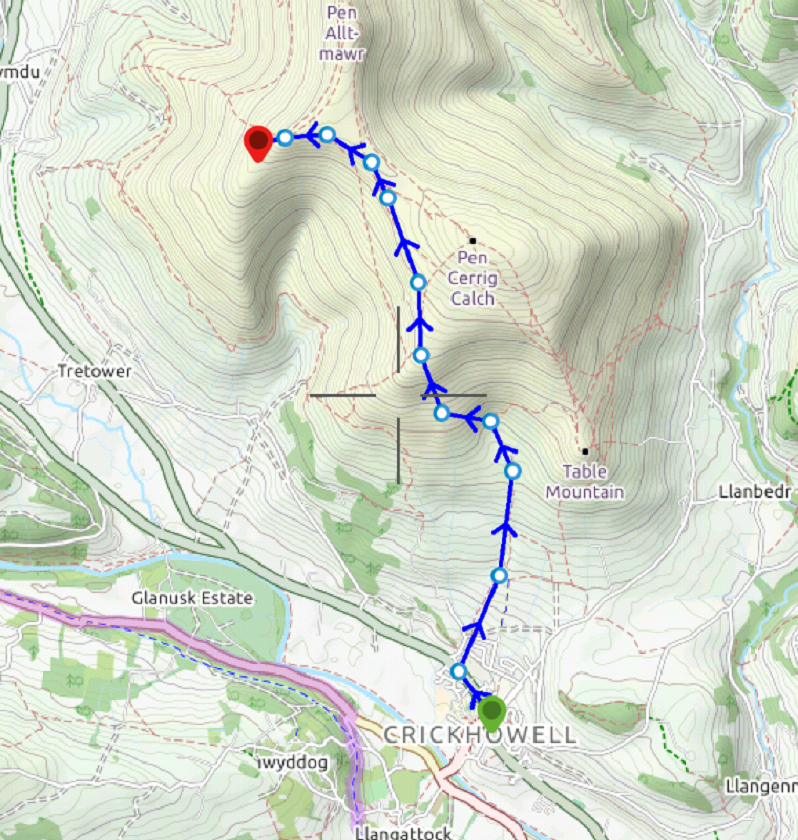
After the walk, you will find plenty of space to launch and might find launching from the grassy plateaus below the top of Pen Allt-mawr easier. The same decisions need to be made in the air as discussed in the opposite direction. If you get low, land and walk back up before you get too low. You might find that top landing and kiting along the footpaths is a more efficient method of moving past the shallow sections.
Vol Biv
This route offers plenty of beautiful wild camping spots. An example is beside Grwyne Fawr Reservoir, a 2.5km walk from the ridge. This spot is well worth top landing and walking for. There is a (tiny) refuge here and plenty of fresh water (still worth treating). Look at a map and you will find plenty of other stunning spots to spend the night.
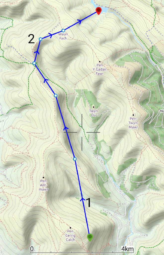
With a light easterly, a nice evening flight and Vol Biv starts on the eastern face of Pen Cerrig Calch (Magic) and follows the easterly side of the ridge to Waun Fach. 500ft above take-off helps with the initial transition [Point 1] and it’s easy soaring beyond here. You will likely slope land high at the head of the valley [Point 2]. From here, mushroom your wing and walk 1km to the top of Waun Fach and enjoy the scenic flight from the top down to the reservoir. Plenty of landing options on the western side of the reservoir.
For your return, pick a ridge of your choice depending on the forecast. A westerly would be ideal to fly back to Crickhowell along the western face of the Black Mountains. You are in the middle of several defined north/south running ridges.
