Status: Members Only |
|
|---|---|
| Site Latitude: N51.658666 | Height ASL Meters: 457m |
| Site Longitude:W003.066258 | Height ASL Feet: 1,500ft |
| Wind Direction: ESE - SSE | Height Top to Bottom Meters: 130m |
| Best Direction: SE | Height Top to Bottom Feet: 425ft |
| Minimum BHPA Rating Hang Gliding: BHPA P rating | Member status: Members Only |
| Minimum BHPA Rating Paragliding: BHPA P rating | OS Grid Reference and Prefix: ST 263 961 |
Latitude: N51.660934
Longitude: W003.056977
For the top of the hill (4×4 required):
From Crumlin or Pontypool on the A472. At Hafodyryns take the minor road which leads to the back of the common and a track. This track is only suitable for vehicles with good ground clearance as it is severely rutted and floods extensively after rain. Once you leave the road, expect to drive for 30 minutes, towards the electricity pylons on the top of the mountain.
Alternative foot access is by public footpath up the front of the hill:
From M4, take junction 25A, follow signs for Cwmbran. Approaching Cwmbran, follow signs to Greenmeadow Community Farm (a white sheep on a brown background). At Community Farm roundabout, carry on straight ahead uphill with the farm on your right. After 200yds turn right onto Thornhill Road. Proceed for 1 mile to where road bends downhill to the right, turn left at this point onto Upper Cwmbran road, passing the Queen Pub on the right. Carry on straight ahead past the bus shelter on left, the road bends uphill. Take the first turning sharp left (marked – single track, no through road). Proceed uphill for quarter of a mile and only park if you can be considerate and inconspicuous, as there is no formal parking arrangement here. Walk up the road until it ends. Shortly after, take the footpath left and walk under the pylons up the hill to take-off.
There is no arranged parking. Always park legally.
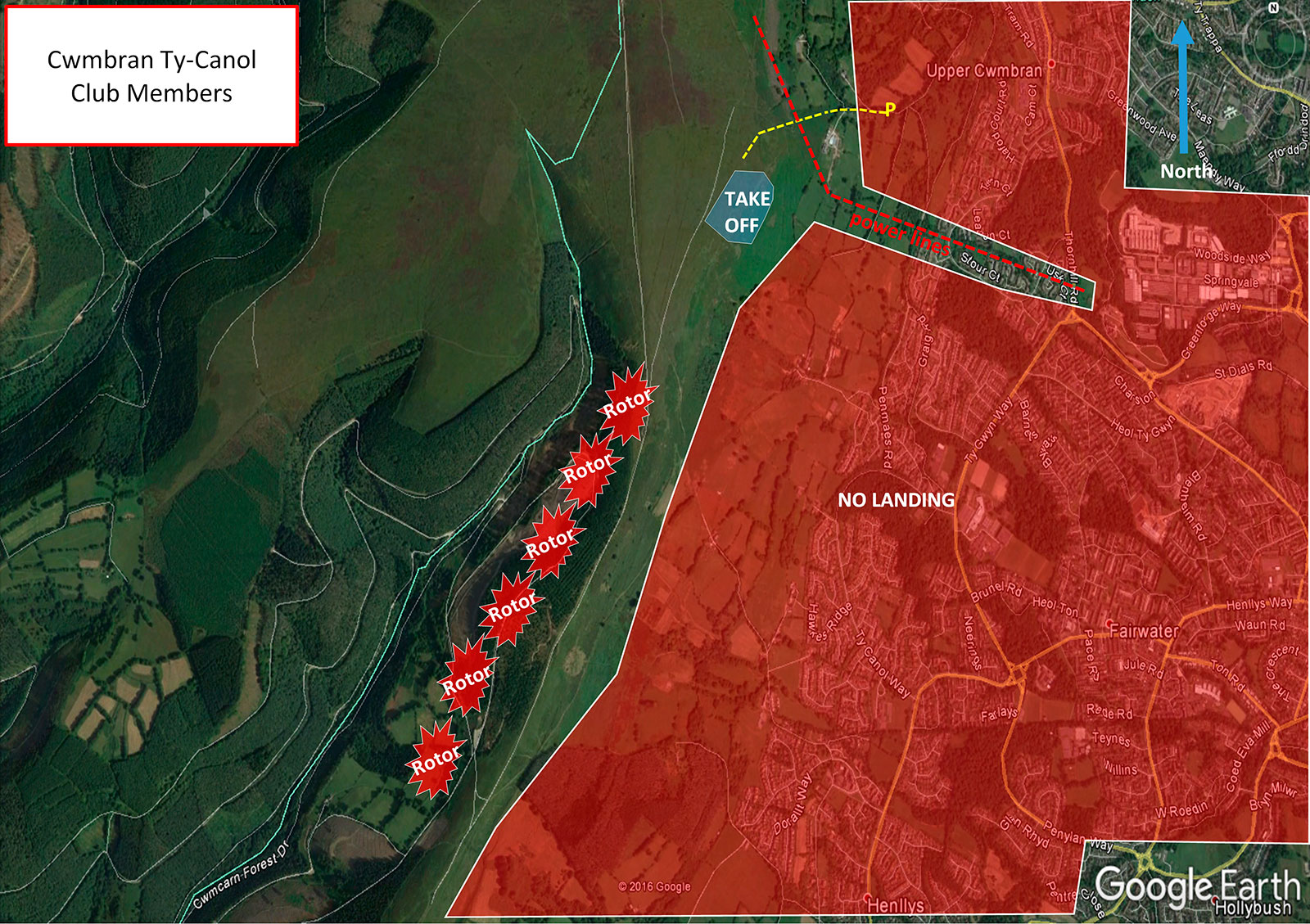
Take-off
Once on top of the mountain walk a further hundred yards along the top, away from the power lines, here you will find plenty of areas to take off from.
Landing
There is no bottom landing for hang glider pilots.
Paragliders can land on the open hillside before the pylons. This can be turbulent especially in strong winds. Do not land in any of the enclosed fields.
Top Landing General
The top landing area (E) is extensive, but the front section slopes gently to the edge. Land well back to avoid an overshoot.
Flying
In the right conditions, good out and return flights can be had right out over to the far side of Cwmbran and also all the way along the mountain towards Bettws.
Hazards
Beware of power lines and pylons. Severe rotor to the south of Llanderfel Farm in winds over 15mph, coupled with a sharp ridge and a forest.
Stick to public rights of way. Avoid walking on the private road (passing south from Llanderfel Farm) – there is a public footpath running parallel 5 meters to the east of it (between the private road and fences). Nearby residents may challenge you otherwise.
SEW Members Only Site. You must have in date membership subscription to SEWHGPGC. SEW helmet sticker to be stuck on your helmet at all times.
TBC.
Site records –
PG – Andrew Price flew 16.6 km on his Gin Rebel 03/09/2010
http://www.xcleague.com/xc/flights/20101970.html
All rights belong to Google Inc. SEWHGPGC is a nonprofit making organisation.
If you require further advice about a particular SEWHGPGC site please contact a Club Coach. Please report all accidents to The Club Safety & Training Officer Steve Millson and the BHPA. Please visit the BHPA for the most current Incident Report Form.
This document is a guide only.
We advise that anyone Hang Gliding and Paragliding conduct a dynamic risk assessment prior to flying any site. This should be continuously re-assessed due to the changeable conditions of the outdoor environment.
All individuals are advised to take the following into account when making their dynamic risk assessment:
Paragliding and Hang Gliding are dangerous sports that can cause serious injury including bodily harm, paralysis and death. Flying SEW sites is undertaken with the full knowledge that Paragliding and Hang Gliding involves such risks. As the pilot you take exclusive responsibility for all risks associated with your part taking in the sport.
Any liability claims towards the club are excluded.
If you are not sure. DO NOT FLY.
In the Mountains/Rivers/Lakes
Dial 999/112 and ask for the Police and then Mountain Rescue. If you are away from the road side then dial 999/112 and ask for the Police and then Mountain Rescue explaining your circumstances. If you cannot make voice calls, you can now contact the 999 Emergency Services by SMS. NB you must register this prior to an emergency.
In an emergency 999 need to know:
Who is Calling?
Your name and mobile number.
What?
Briefly, what is the problem, including the state of the casualty. Ensure you use the buzzword Fall From Height
and Remote Location.
Where?
Mynydd Twyn Glas Mountain 3.6km West of Cwmbran, near the A4051.
