Status: Open |
|
|---|---|
| Site Latitude: N51.744371 | Height ASL Meters: 430m |
| Site Longitude: W003.2451376 | Height ASL Feet: 1400ft |
| Wind Direction: W – NW | Height Top to Bottom Meters: 75m |
| Best Direction: WNW | Height Top to Bottom Feet: 250ft |
| Minimum BHPA Rating Hang Gliding: BHPA CP rating with supervision | Member status: Open Site |
| Minimum BHPA Rating Paragliding: BHPA CP rating | OS Grid Reference and Prefix: SO 141 058 |
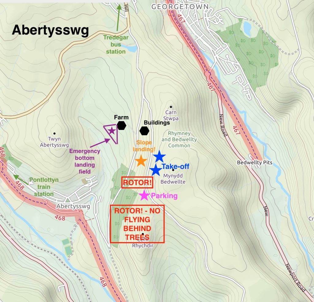
From Tredegar on minor roads towards Markham, or North from Markham to Tredegar. Due South of NP22 5BQ but on the more easterly single track road.
Park along by the road near the corner where it is flat ensuring enough space is left for gliders landing. Do not block farm roads.
Take-off
Take-off is on the west side of Mynydd Bedwellte which overlooks Abertysswg and faces WNW. An under-rated and under used site – it takes similar wind directions to M.Fochriw.
Take-off from the top of the M.Bedwellte hill, or slightly further down. Don’t forget to account for the road and any traffic using it. There will not be as much ridge lift if the wind is South of West, and there could be more turbulence as the wind is off too. Care and control is needed when launching hang gliders in strong winds, as the take-off is narrow and vehicles are close by. Paragliders do not have this problem. If you are not sure of the true speed and direction of wind then check at the top of the hill first.
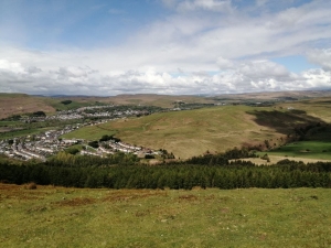
Looking out from the take-off.
Landing
Top landing is easiest on top of the hill which is about 120ft higher than takeoff. Sometimes the area behind the road can be used.
Top landing a hang glider in front of the road south of takeoff requires a great deal of experience and precision and is not recommended. It is easy on a paraglider.
Slope landing is possible for paragliders by the side of the road at the bottom of the hill marked on the map. Be careful of cars if you are landing too close to the road. This area is small, uneven and slopes. It is very difficult for hang gliders not recommended for hang gliders.
The emergency bottom landing field (triangular shaped field marked with purple star on the map) is available outside of the lambing season. Be aware there is are power lines running north towards the farm. Always leave by the gate at the bottom of the field, and carry gliders up to the road. This is a long carry out over rough ground. Please don‘t park on the farm track. Note if the farm gates are shut the farm security dogs are loose, do not enter the farm at these times.
Flying
More than 10 gliders can be accommodated in the right conditions. Just be aware that it can be turbulent in strong winds. Wave is quite common – like many of the valleys sites.
The sites gives you a great view across the valley to the Pontlottyn site directly in front and then M.Fochriw in front of that where you may see other wings flying.
Look out for the red kites and other birds of prey which frequent this site and mark the thermals for you.
You will probably find the most ridge lift comes from the steeper section of the hill just in front of the road (as you look out).
Thermals reliably trigger from just in front of this and comes up off the conifers and the hill in front of the road. A good tactic is to push out front to catch a thermal and if you don’t manage this then you can return to the steeper section of ridge in front of the road.
Hazards
Beware of moving vehicles and rotor from parked cars if you top land close to the road. Stay clear of the lee side of the trees as there can be significant turbulence off them in strong winds. The quarry to the South can also be turbulent and is to be avoided by low air time pilots.
Be aware of power lines and telegraph poles between the lower road and landing field.
Do not land in the field adjacent to and to the South of take-off. If you accidentally land in any field carry out by the gate. Do not climb walls or fences. This site is sometimes used by model aircraft pilots, please respect their right to fly as well as your own.
Open site – This site may be flown by suitably insured visiting hang glider & paraglider pilots. This site is flown with the kind permission of the Trustees of the Llanover Estate.
Llanover Estate
HG record – Justin Needham flew 137km on his La Moette Topless.
PG record – Alex Kennedy flew 28.3 km on his Nova Sector to just past Raglan castle.
Maps courtesy of OpenStreetMap Contributors.
If you require further advice about a particular SEWHGPGC site please contact a Club Coach. Please report all accidents to The Club Safety & Training Officer Steve Millson and the BHPA. Please visit the BHPA for the most current Incident Report Form.
This document is a guide only.
We advise that anyone Hang Gliding and Paragliding conduct a dynamic risk assessment prior to flying any site. This should be continuously re-assessed due to the changeable conditions of the outdoor environment.
All individuals are advised to take the following into account when making their dynamic risk assessment:
Paragliding and Hang Gliding are dangerous sports that can cause serious injury including bodily harm, paralysis and death. Flying SEW sites is undertaken with the full knowledge that Paragliding and Hang Gliding involves such risks. As the pilot you take exclusive responsibility for all risks associated with your part taking in the sport.
Any liability claims towards the club are excluded.
If you are not sure. DO NOT FLY.
In the Mountains/Rivers/Lakes
Dial 999/112 and ask for the Police and then Mountain Rescue. If you are away from the road side then dial 999/112 and ask for the Police and then Mountain Rescue explaining your circumstances. If you cannot make voice calls, you can now contact the 999 Emergency Services by SMS. NB you must register this prior to an emergency.
In an emergency 999 need to know:
Who is Calling?
Your name and mobile number.
What?
Briefly, what is the problem, including the state of the casualty. Ensure you use the buzzword Fall From Height
and Remote Location.
Where?
OS Grid Ref: SO 141 058
South of Tredegar on the narrow road towards Markham
