Status: Members Only |
|
|---|---|
| Site Latitude: N51.921697 | Height ASL Meters: 366m |
| Site Longitude:W002.820922 | Height ASL Feet: 1200ft |
| Wind Direction: SW-NNW | Height Top to Bottom Meters: 300m |
| Best Direction: NW | Height Top to Bottom Feet: 980ft |
| Minimum BHPA Rating Hang Gliding: BHPA Pilot rating | Member status: Members Only |
| Minimum BHPA Rating Paragliding: BHPA Pilot rating | OS Grid Reference and Prefix: SO 250 437 |
The easiest approach is from the East, turn off the B4521 at Broad Oak and follow signs to Garway, proceed through Garway Village and take the first right, signposted Garway Hill. Continue on this road for 1.8 miles at 51.920580, -2.804650 take the left hand turn up the track opposite postbox and wooden footpath sign. Proceed up the track, the turning area and parking is at the end.
Garway Hill Parking is shared with other users of the common and limited to around 10 cars. Because of the limited parking and the remote location of the site for returning to after an XC, car sharing is recommended.
There are two suitable alternatives for parking. (1) At the turn off up the track the road verges are sufficiently wide to park 4 or 5 cars, again this parking option is also used by walkers and local residents. (2) In Garway village there is parking at The Moon of Garway pub GR
Latitude: N51.91905
Longitude: W002.809116
Latitude: N51.92057
Longitude: W002.804509
Latitude: N51.900400
Longitude: W002.779013
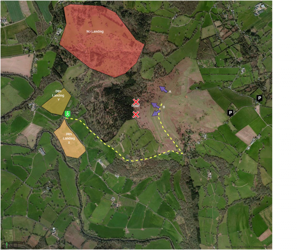
Take-off
The main NW take-off (A) is to the North West of the trig point and identified as the grass path and a small grass clearing within the braken.
A second take-off area (B) is on the shoulder of the hill to the SW as the hill brow bends around to the South.
A further take-off is available lower down on the SW side which can be used in stronger wind conditions.
Due to the level of braken on the hill there is a limitation to the number of gliders than can be laid out.
Landing
Top landing is recommend. The hill to the South of Take-off B on the map provides as slightly lower slope with the greatest clearing of bracken.
Two bottom landing fields have been negotiated for use. Both fields are owned by the same famer from Great Corras farm as marked on the map. Given a choice we recommend using the field marked as X on the map, this landing field provides greater potential for finding lift and is flatter. Field Y slopes away to the South West and is 40m higher than X. Please exit both bottom landing fields at the gates near the bottom of the footpath marked as the route back to take-off.
Please note there is limited phone signal in the bottom landing fields.
DO NOT – pilots are strictly prohibited from attempting to land within the Deer Park of Kentchurch Court. This area is very sensitive and is used by the Kentchurch Estate for shooting all year round including rifle target practice. It also is enclosed by high deer fence.
Top Landing General
South East Wales sites often have very large, undefined take off and top landing areas, which may change position according to conditions. To avoid the potential for collision, pilots making a top landing should keep well away from gliders taking off, who may in some cases have limited visibility.
Flying
This is essentially a cross country site and is not recommend as a ridge soaring hill due to the ridge lift being limited to around 4 gliders.
The hill is also shared with a small group of model glider pilots that have a good understanding and relationship with the paraglider pilots. The model pilots are useful for indicating working lift and assuming the paraglider pilots intend to go XC will kindly move the models out of thermals to allow the paraglider pilots to climb out from the hill.
On light wind days the thermals will often release from the tree line in front of the hill and a committed launch and glide may be required to connect with them. The lower slopes of the South facing hill running along the Monnow river valley will also generate thermals, on sunny light wind days it has been possible to connect with further thermals releasing from the edge of the river valley heading SE beyond Skenfrith.
Hazards
The woodland to the SW below launch causes some turbulence in stronger wind, with an area of rota directly behind the trees. There are also some obvious smaller trees on the slope just below launch which reduce the ridge soaring capacity of the hill.
None noted.
This site take-off is still awaiting final approval from the stakeholders. However a legal dispute between the Lord of the Manor and Commoners is preventing any final approval being concluded. As the site is already used and the bottom landing agreed, South East Wales has published the sites guide to ensure sensible and safe use of the site.
Take-Off
Lord of the Manor: James De Labilliere
Commoners: Garway Commoners represented by Parish Council
Bottom Landing:
Tenant Farmer: Rob Watkins
A number of 200K+ flights have been achieved by Paragliders in 2017. A lack of airspace combined with the flat landscape could make this an excellent choice, although the immediate area down wind of Garway Hill can be tricky to cross. On 15th August 2017, new site records were achieved by Harry Bloxham for an open distance flight of 254K to Thurston. http://www.xcleague.com/xc/flights/20173488.html and a 240K flight to goal at Bury St Edmunds by Graham Steel http://www.xcleague.com/xc/flights/20173489.html
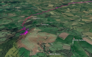
This pilot takes a one-way ticket in a strong thermal out of Garway Hill.
Retrieves can be frustrating due to the lack of public transport around Garway Hill. Flying 10 km could take you longer to get back than flying 50 km.
All rights belong to Google Inc. SEWHGPGC is a nonprofit making organisation.
If you require further advice about a particular SEWHGPGC site please contact a Club Coach. Please report all accidents to The Club Safety & Training Officer Steve Millson and the BHPA. Please visit the BHPA for the most current Incident Report Form.
This document is a guide only.
We advise that anyone Hang Gliding and Paragliding conduct a dynamic risk assessment prior to flying any site. This should be continuously re-assessed due to the changeable conditions of the outdoor environment.
All individuals are advised to take the following into account when making their dynamic risk assessment:
Paragliding and Hang Gliding are dangerous sports that can cause serious injury including bodily harm, paralysis and death. Flying SEW sites is undertaken with the full knowledge that Paragliding and Hang Gliding involves such risks. As the pilot you take exclusive responsibility for all risks associated with your part taking in the sport.
Any liability claims towards the club are excluded.
If you are not sure. DO NOT FLY.
In the Mountains/Rivers/Lakes
Dial 999/112 and ask for the Police and then Mountain Rescue. If you are away from the road side then dial 999/112 and ask for the Police and then Mountain Rescue explaining your circumstances. If you cannot make voice calls, you can now contact the 999 Emergency Services by SMS. NB you must register this prior to an emergency.
In an emergency 999 need to know:
Who is Calling?
Your name and mobile number.
What?
Briefly, what is the problem, including the state of the casualty. Ensure you use the buzzword Fall From Height
and Remote Location.
Where?
Garway Hill
SO 250 437
Near The Moon Garway pub at
