Status: Open |
|
|---|---|
| Site Latitude: N51.724323 | Height ASL Meters: 430m |
| Site Longitude: W003.3357105 | Height ASL Feet: 1440ft |
| Wind Direction: WNW – WSW & N | Height Top to Bottom Meters: 275m |
| Best Direction: W | Height Top to Bottom Feet: 900ft |
| Minimum BHPA Rating Hang Gliding: BHPA CP rating | Member status: Open Site |
| Minimum BHPA Rating Paragliding: BHPA CP rating | OS Grid Reference and Prefix: SO 078 038 |
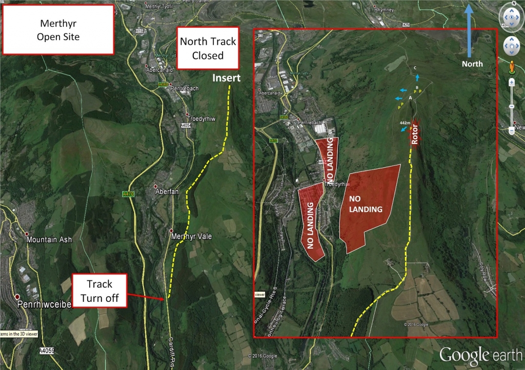
4/2/23 Note both access tracks have substantial locked gates and CCTV. The club have negotiated access and keys are available via the Sewhgpgc Webcollect website, Please log in and look under events, read the rules and follow the instructions. Without keys you will need to walk up from the bottom or near the gates, park considerately. Both access tracks are rough anyway, the north being the roughest. It is best to use a vehicle with high ground clearance or ideally someone elses – sumps have been lost in the past.
The south entrance is located at co-ordinates N51.674630, W003.330329. This is located on the A4054 (Cardiff Road). The entrance is located 0.19 miles south of Merthyr Vale and 0.82 miles north of Edwardsville from the point where you exit the residential areas. At the track junction travel 3.75 miles up the rough track to the top of Merthyr common and turn left off road to the Parking area. Ensure you indicate early for the south entrance to minimise any potential road incidents as the turning is sharp, not sign posted and in a national speed limit zone.
Latitude: N51.723944
Longitude: W003.335460
Park as per map above. Either in front of the mound south of the north most end, Or alongside the SW/NE track to the north of the Hang Glider top landing area
Do not drive up to take-off to unload. Park at the base of the mound to the south of take-off. Do not encroach onto the
hang glider Landing area (A)
When operating vehicles at this site, keep an eye out for gliders coming into land. Park at the P’s on the site map, co-
ordinates above. Basically aside the northerly most track, or in front of the mound as per the P’s on the map image.
Take-off
West: When rigging or inflating paraglider please watch out hang gliders overshooting the top landing. Merthyr is much
steeper than Fochriw (immediately behind the hill) with a larger venturi – consequently for a given wind it may be much
stronger on take-off.
North: This take-off is mainly used for training top-to-bottoms and can only accommodate 1 or 2 wings.
Southwest: A shallow take-off for hang gliders from the top of the ridge. Watch out for paragliders launching lower down.
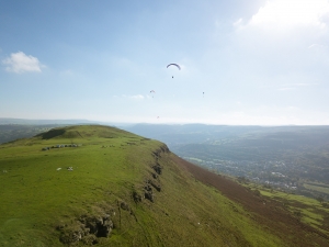
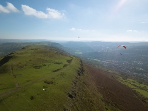
A view of the Merthyr Common take-off (nearly anywhere along the ridge). Photo courtesy of Marcus Woodbridge.
Landing
Top landing areas (A & B) are extensive and fairly flat. Watch out for rotor towards the top of the track on the right hand
side. Paraglider slope landings can be difficult because of the steep rough ground and debris dumped in the bracken. There
is no bottom landing field, but shoulder landings are possible at (C) to the north of the main ridge. This shoulder is
frequently used for ab-initio training so keep a sharp lookout for beginners and try to land to the east of the track.
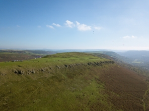
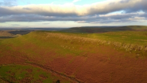
A view of the Merthyr Common ridge – note the bracken was brown at this time of year. Photo courtesy of Marcus Woodbridge.
Top Landing General
South East Wales sites often have very large, undefined take off and top landing areas, which may change position according to conditions. To avoid the potential for collision, pilots making a top landing should keep well away from gliders taking off, who may in some cases have limited visibility.
Looking north along the Merthyr ridge in the evening sunset. You can see the open cast mine to the north (top) and also Mynydd Fochiw (another paragliding site) to the east (right of image). Photo courtesy of Sparky Mark Baldwin.
Flying
A friendly site generally. The main ridge has a large capacity and can support more than 50 gliders in good conditions.
Capacity falls significantly as the wind goes off to the north or south and the lift band narrows. The north face is small and
primarily used for training, but can be soared in the right conditions. When going “over the back” at Merthyr, watch out for
paramotors taking off or landing at Bedlinog.
An image of flying off the Merthyr Common ridge looking south. Note that thermals can trigger off the higher mound just behind the ridge. Photo courtesy of Marcus Woodbridge.
Hazards
The usual hazards associated with a cliff edge in strong winds. There can be a sharp wind gradient in the top landing area, and strong sink in the lee of the hill. Do not land too far back.
Beware of ticks, especially if you are sat out the ground for significant peroids – sheep and horses graze on the common and these parasites have been found on the top.
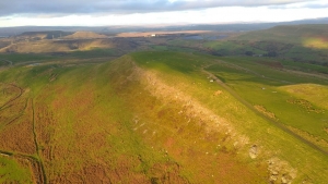
An overview of the Merthyr ridge – careful of the rocks and sharp wind gradient due to the shape of the terrain. Photo courtesy of Sparky Mark Baldwin.
The emergency landing /sports field adjacent to the railway line as of Feb 2023 is currently being used as base for the railway overhead electric upgrade.
So is totally out of bounds, have an alternative plan and make any decisions early!
Open site – This site may be flown by suitably insured visiting hang glider & paraglider pilots.
TBC
This site is excellent for getting away on XC and big distances have been flown into England over the Severn. You’ll need to fly out over the valleys before reaching the flat lands, seeing some spectacular views of the western Beacons to the west, the High Beacons including Pen Y Fan to the North, Cardiff and the Severn estuary to the south, before passing Abergavenny and the Black Mountains, viewing the Malverns and the river Wye and then hopefully crossing the river Severn at a narrow point…
Site records
HG – Carl Wallbank flew 338.73km on a Moyes Rx 3.5 on 24th June 2015.
PG – Karoly Megyesi flew 169.7 km on his Niviuk Icepeak 7 Pro on 23 July 2015.
http://www.xcleague.com/xc/flights/20152576.html?vx=19
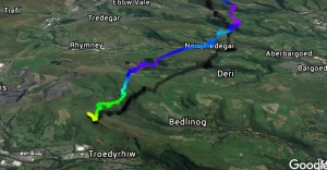
A pilot leaves Merthyr Common across the valleys and over other flying sites including Mynydd Fochriw, Pontylottyn, Abertysswg (Mynydd Bedwellte), Ebbw Vale, Mynydd Carn-y-Cefn (of the Blaina ridge), Blaenavon (Coity Mountain) and finally the Blorenge.
For retrieves the nearest train station is Troed-y-Rhiw on the Merthyr Tydfil line (although you may have chosen to leave a car at Merthyr Vale station instead).
All rights belong to Google Inc. SEWHGPGC is a nonprofit making organisation.
If you require further advice about a particular SEWHGPGC site please contact a Club Coach. Please report all accidents to The Club Safety & Training Officer Steve Millson and the BHPA. Please visit the BHPA for the most current Incident Report Form.
This document is a guide only.
We advise that anyone Hang Gliding and Paragliding conduct a dynamic risk assessment prior to flying any site. This should be continuously re-assessed due to the changeable conditions of the outdoor environment.
All individuals are advised to take the following into account when making their dynamic risk assessment:
Paragliding and Hang Gliding are dangerous sports that can cause serious injury including bodily harm, paralysis and death. Flying SEW sites is undertaken with the full knowledge that Paragliding and Hang Gliding involves such risks. As the pilot you take exclusive responsibility for all risks associated with your part taking in the sport.
Any liability claims towards the club are excluded.
If you are not sure. DO NOT FLY.
In the Mountains/Rivers/Lakes
Dial 999/112 and ask for the Police and then Mountain Rescue. If you are away from the road side then dial 999/112 and ask for the Police and then Mountain Rescue explaining your circumstances. If you cannot make voice calls, you can now contact the 999 Emergency Services by SMS. NB you must register this prior to an emergency.
In an emergency 999 need to know:
Who is Calling?
Your name and mobile number.
What?
Briefly, what is the problem, including the state of the casualty. Ensure you use the buzzword Fall From Height
and Remote Location.
Where?
OS Grid Ref : SO 078 038 (for takeoff)
