Status: Open |
|
|---|---|
| Site Latitude:N51.7376100 | Height ASL Meters:420m |
| Site Longitude:W003.2815698 | Height ASL Feet:1378ft |
| Wind Direction:NNE – ENE | Height Top to Bottom Meters:190m |
| Best Direction: NE | Height Top to Bottom Feet:623ft |
| Minimum BHPA Rating Hang Gliding: BHPA CP rating | Member status:Open Site |
| Minimum BHPA Rating Paragliding:BHPA CP rating | OS Grid Reference and Prefix:SO 115 052 |
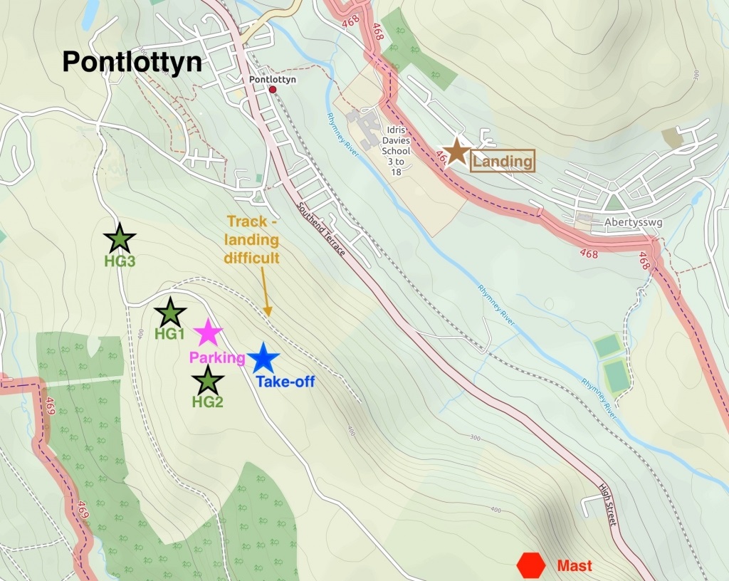
A465 Take exit signposted A469 Bargoed / B4257 Rhymney.
At the roundabout follow the A469 signposted to Pontlottyn, shortly after the turning for the B4257 on the left take the right turn signposted to Fochriw. Continue up the steep hill (Fochriw Road) for 0.7 miles, keep driving over the cattle grid to the top parking area.
Drive up the track to takeoff, then park along the edge of the track ensuring enough space is left for gliders landing or being carried forward across the track.
Take-off
The take off located on the steep north east face of Cefn y Brithdir, overlooking Pontlottyn.
The take-off area is large and flat and the hill has a nice rounded front. No real obstructions, but be aware of the high voltage power lines running along the bottom of the hill in front of take-off.
Landing
The paragliding top landing area is large but be aware of being blown back onto the road and parked cars, also of gliders taking off ahead at the hill edge. It is possible to land a PG on the track to avoid a lengthy walk up – but this requires significant skill and experience.
Hang gliders should aim to land in area HG1 towards the rear of the hill. Note the gentle slope towards the line of parked cars/road and take-off. Overshooting the landing area should be avoided but it is normally clearer towards the north end.
Area HG2 is large and reasonably flat and slightly higher than the road and car park. If you overshoot it is a long way to the front down a shallow slope towards take-off. Be aware of cars on the road, pilots taking off, PG’s landing and pilots soaring low at the hill edge.
Area HG3 on the shoulder is an option if you do not have enough height to be able to use H1 or H2. There is no safe overshoot option and you will need to land close to the road. It is worth taking note of the lay of the land on the way to take-off. If not staying up, head for the bottom landing (see map) in good time as there are no alternative fields on the way if you get low.
The bottom landing field slopes uphill, so approach with plenty of airspeed. A “fly on the wall” type flare will be required on a hang glider.
Flying
A lovely site to fly with a view over to Abertysswg. The Rhymney River sits in the valley below. Wave is not uncommon, and good height gains are possible even in winter.
Lift drops off dramatically when the wind is off the hill. The site can be affected by a sea breeze – you’ll see the sea breeze front approaching from the south.
It is possible to fly across the valley to the quarry and pick up lee side thermals from the rock face after it has been in sun.
The wind turbines on the hills in front cannot be relied upon to judge wind speed as blades are adjusted to give slow rotation sometimes.
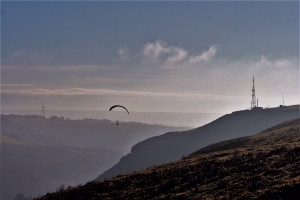
Looking south from the Pontlottyn take-off. Photo courtesy of Alan Hole.
Hazards
Watch out for the power lines running along the bottom of the hill in front of take-off and the transmitter mast towards the south end of the ridge. Beware of the steep embankment on the approach to the bottom landing field
Cars park immediately next to the landing area, so don’t get dragged into them, or land in their lee.
None.
Open site – This site may be flown by suitably insured visiting hang glider & paraglider pilots.
Site record
PG – Graham Richards flew 28.3 km on his Gradient Aspen 3 on 13 September 2009.
http://www.xcleague.com/xc/flights/20091535.html
Maps courtesy of OpenStreetMap Contributors.
If you require further advice about a particular SEWHGPGC site please contact a Club Coach. Please report all accidents to The Club Safety & Training Officer Steve Millson and the BHPA. Please visit the BHPA for the most current Incident Report Form.
This document is a guide only.
We advise that anyone Hang Gliding and Paragliding conduct a dynamic risk assessment prior to flying any site. This should be continuously re-assessed due to the changeable conditions of the outdoor environment.
All individuals are advised to take the following into account when making their dynamic risk assessment:
Paragliding and Hang Gliding are dangerous sports that can cause serious injury including bodily harm, paralysis and death. Flying SEW sites is undertaken with the full knowledge that Paragliding and Hang Gliding involves such risks. As the pilot you take exclusive responsibility for all risks associated with your part taking in the sport.
Any liability claims towards the club are excluded.
If you are not sure. DO NOT FLY.
In the Mountains/Rivers/Lakes
Dial 999/112 and ask for the Police and then Mountain Rescue. If you are away from the road side then dial 999/112 and ask for the Police and then Mountain Rescue explaining your circumstances. If you cannot make voice calls, you can now contact the 999 Emergency Services by SMS. NB you must register this prior to an emergency.
In an emergency 999 need to know:
Who is Calling?
Your name and mobile number.
What?
Briefly, what is the problem, including the state of the casualty. Ensure you use the buzzword Fall From Height
and Remote Location.
Where?
The common due 1km south of pontlottyn town
OS grid Ref: SO11600 05051
or lat/long : 51.737169,-3.281585
