Status: Open |
|
|---|---|
| Site Latitude:A N51.864510 B N51.868899 C N51.857390 D N51.867422 | Height ASL Meters:662-726m |
| Site Longitude:A W003.357222 B W003.352415 C W003.374659 D W003.378647 | Height ASL Feet:2172-2382ft |
| Wind Direction:E-SW | Height Top to Bottom Meters:233m |
| Best Direction: SE-SW | Height Top to Bottom Feet:764ft |
| Minimum BHPA Rating Hang Gliding: BHPA CP rating (considered unsuitable due to the long walk up). | Member status:Open Site |
| Minimum BHPA Rating Paragliding:BHPA CP rating | OS Grid Reference and Prefix:E SO 065 193 W SO 054 185 |
Latitude: N51.849156
Longitude: W003.370955
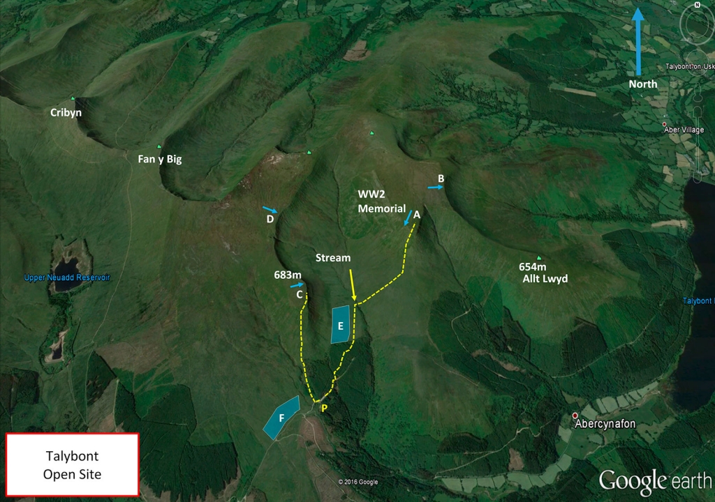
Take the turning to the south on the A40 signposted Talybont-on-Usk. It is about 5 miles from Brecon and 7 miles from Crickhowell. Drive to Talybont village. At the T junction, turn right past 2 pubs. Turn left up and over the canal swing bridge and follow the road around past the Tal-y-Bont Reservoir for approx 6 miles till it turns left over a bridge and steepens dramatically. Follow it to the top, where there’s a big car park on the right. Park here (P).
There is a large purpose built car park (P).
Walk:
East take off is 2.29km walk minimum with 280m height gain and a stream crossing.
West take off is 1.07km walk minimum with 240m height gain.
Ensure you a physically fit and competent in a changeable outdoor environment to undertake such a walk.
Take-off
The Talybont site is actually the mountain Waun Rydd which is a flat plataeau to the east of Pen y Fan.
A
SW – Cwar y Gigfran (‘Quarry of the crow’) & SE – Gwalciau’r Cwm top is clear and easily top-landable anywhere. Go out of the end of the car park, along the forestry track and take the path off to the left, (it is often muddy and may not look like the appropriate route) through to open country and a stile. Head along a footpath across the open ground and drop down a gully to the stream. Cross this and carry on across the open ground to the base of the hill. Head steeply up to the top of the hill – a hard climb.
B
B (Craig y Fan) is at the top of a long spine back ridge. The east facing ridge can be flown in E but the Talybont site (Waun Rydd) is most commonly flown in a SW.
C
SW SE Can be used to hop across to A (which is a better ridge ) go back west out of the car park entrance and turn immediately right on a clear trail to the top of the hill. This walk-up shouldn’t take much more than half an hour.
D
E – SE a very obvious large bowl with a well-worn path running around it.
Landing
Top landing is possible, the entire top of the mountain is flat. Watch out for peat hags and for rotor behind steep slopes. Land at edge or 50m back.
Bottom landing is at E or F. Be aware that the ground may be sloping away from you.
Top Landing General
South East Wales sites often have very large, undefined take off and top landing areas, which may change position according to conditions. To avoid the potential for collision, pilots making a top landing should keep well away from gliders taking off, who may in some cases have limited visibility.
Flying
One of the area’s best XC sites on light or nil wind days with a mainly Southerly component (SW to SE).
Hazards
Talybont is quite ‘alpine’ in character often with vigorous thermals and not much capacity to accommodate even moderate meteo winds. If there is a breeze in the car park when you arrive it’s very likely the hill will be blown out.
In addition, Talybont can have significant anabatic flow for a UK site which can compete with the meteo wind. This can give the effect of a sudden change of wind direction with pilots inadvertently finding themselves in the lee and getting ‘flushed’. If you encounter significant sink do not attempt to side land. Fly out from the ridge to look for lift or land and walk back up. When flying near the hill, or for top landings, it is strongly recommended that a GPS be used to determine the true wind direction.
Pilots are reminded that any flights that cannot be considered to be “ridge soaring”, or during the take-off and landing phases must be carried out at more than 1,000 ft over a built-up area or otherwise more than 500ft from people, vehicles, vessels and structures. This rule applies to paragliders, hang gliders and speed wings
Open site – This site may be flown by suitably insured visiting hang glider & paraglider pilots.
This site is flown with the kind permission of- Royal Artillery.
This site has a lot of potential for spectacular XC flights, flying over Pen y fan and the Brecon beacons. The ground drops away sharply to the East leaving lots of height to play with, but beware there is usually sink over Brecon. On light wind days it is possible to go in almost any direction so triangles and out and returns are a distinct possibility.
NB On a potentially good XC day it’s a good idea to leave a car in the village and share a lift to the car park. It can be difficult to get back to the car park after an XC.
Site record
PG – ‘The Brother’s Price’ (Lewis and James Price) flew an inseparable 119.3 km together on a memorable BCC day on 19 May 2018.
http://www.xcleague.com/xc/flights/20181815.html?vx=37
http://www.xcleague.com/xc/flights/20181816.html?vx=37
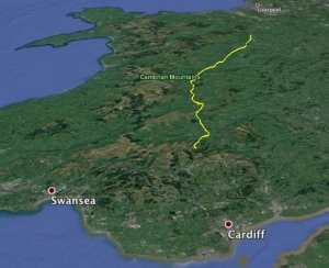
The Brother’s Price flying across most of Wales in a southerly wind.
Useful information for the Brecon Beacons:
The Brecon Beacons National Park – www.breconbeacons.org
TrawsCambria [free weekend travel] – www.trawscambria.info (a 2 hour service from Newtown/Llandrindod Wells (704) connecting with X43 in Brecon which goes to Abergavenny or Merthyr Tydfil and Cardiff, or take the 714 to get to Llandovery.
National Express – www.nationalexpress.com
Stagecoach – www.stagecoachbus.com
All rights belong to Google Inc. SEWHGPGC is a nonprofit making organisation.
If you require further advice about a particular SEWHGPGC site please contact a Club Coach. Please report all accidents to The Club Safety & Training Officer Steve Millson and the BHPA. Please visit the BHPA for the most current Incident Report Form.
This document is a guide only.
We advise that anyone Hang Gliding and Paragliding conduct a dynamic risk assessment prior to flying any site. This should be continuously re-assessed due to the changeable conditions of the outdoor environment.
All individuals are advised to take the following into account when making their dynamic risk assessment:
Paragliding and Hang Gliding are dangerous sports that can cause serious injury including bodily harm, paralysis and death. Flying SEW sites is undertaken with the full knowledge that Paragliding and Hang Gliding involves such risks. As the pilot you take exclusive responsibility for all risks associated with your part taking in the sport.
Any liability claims towards the club are excluded.
If you are not sure. DO NOT FLY.
In the Mountains/Rivers/Lakes
Dial 999/112 and ask for the Police and then Mountain Rescue. If you are away from the road side then dial 999/112 and ask for the Police and then Mountain Rescue explaining your circumstances. If you cannot make voice calls, you can now contact the 999 Emergency Services by SMS. NB you must register this prior to an emergency.
In an emergency 999 need to know:
Who is Calling?
Your name and mobile number.
What?
Briefly, what is the problem, including the state of the casualty. Ensure you use the buzzword Fall From Height
and Remote Location.
Where?
Due to the size of this site and the potential dangers of operating in a mountainous environment with the inherent changeable conditions associated with such environments. Individuals are advised to be competent at calling in the emergency services and giving co-ordinates themselves.
